
Quick Answer
Hajin has military bases in the west, farmland in the southwest, and city districts in the east. On the MW4 DMZ Hajin map, look for Imjin Farmland toward the lower left, Wolves Stadium near the bottom center, and Haneul Nuclear Reactor in the northeast. Use the map grid to call out locations to your squad: D7 identifies Imjin Farmland.
What does the MW4 DMZ Hajin map look like?
Hajin combines fortified military installations, rural floodplains, mountain terrain, industrial facilities, and dense city blocks.
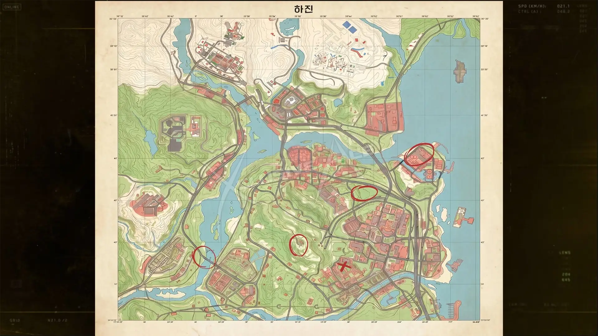
The overhead map gives you Hajin's outline for orienting your route.
Shown at 02:28 in TheXclusiveAce’s video.The Hajin River begins in the western mountains and flows east and south toward the sea. The western side includes North Korean military territory, while the eastern city districts sit in former South Korean territory. You will cross very different terrain as you move between them: open rice fields demand careful use of cover, while The Grid brings rooftop engagements and close street fighting.
Where are the main MW4 DMZ locations in Hajin?
The prison and air base occupy the northwest and west, while Hajin City's major districts spread across the eastern side.
| Main location | Position | Landmark or terrain |
|---|---|---|
| 14th Political Prison | Northwest Hajin | Plateau; Y-shaped Citadel |
| Chang-san Air Base | West Hajin | Granite hillside; underground bunker |
| Deadtown | Southwest Hajin | Abandoned agricultural town |
| Imjin Farmland | South-southwest Hajin | Rice fields; Rice Mill |
| Cheongun Village | North Hajin | Heavenly Luck Casino |
| Mirae General Hospital | North-central Hajin | Hospital; adjacent train station |
| Cheonwang Peak Array | Central Hajin | Flat summit; communications array |
| Haneul Nuclear Reactor | Northeast Hajin | Irradiated reactor complex |
| NuriGO Mall | Northeast Hajin City | Surface and underground shopping |
| The Grid | Central Hajin City | Barricades; high-rise buildings |
| Songdo Wharf | East Hajin City | Market; pier; lighthouse |
| Wolves Stadium | South-central Hajin City | Ruined baseball stadium |
| Hajin River Heights | Southeast Hajin | Apartments; narrow shopping streets |
Imjin Farmland: lower left and D7
Imjin Farmland sits on the south-southwestern floodplain, with exposed rice fields, waterways, farms, roads, and railway lines around the Rice Mill.
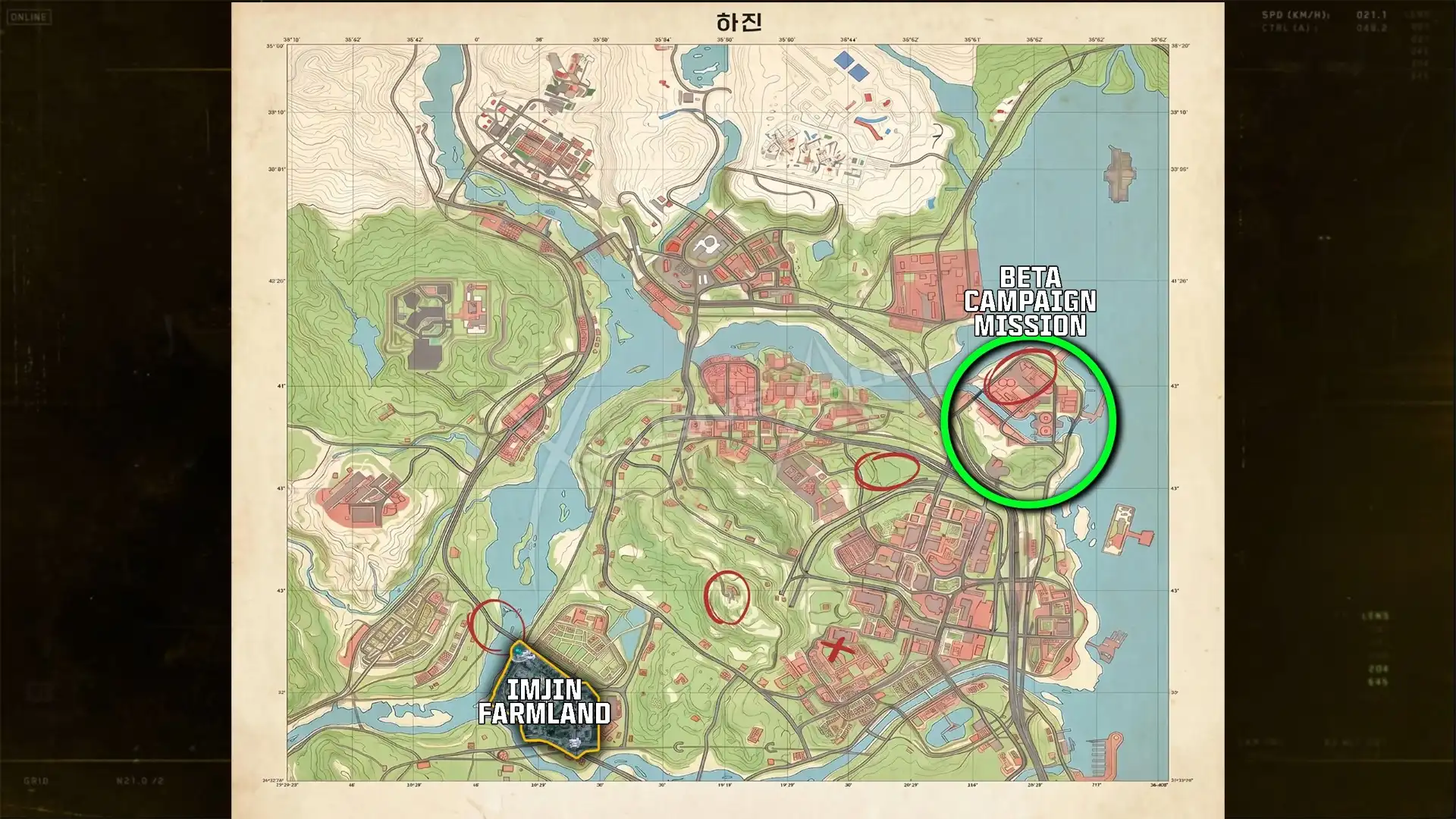
Look toward the lower left of the map for the farmland.
Shown at 03:11 in TheXclusiveAce’s video.The Rice Mill gives you an elevated view across the fields. Approach through cover and the surrounding warehouses, then switch to close-range weapons inside. The farmland exterior has a Low threat level, but the mill is Medium. Long sightlines and limited cover make a straight run across open ground an exposed approach; watch for vehicles before pushing out.
Wolves Stadium: bottom center, below The Grid
Wolves Stadium lies in south-central Hajin City, with an open-air Theatre immediately north and Hajin River Heights farther south.
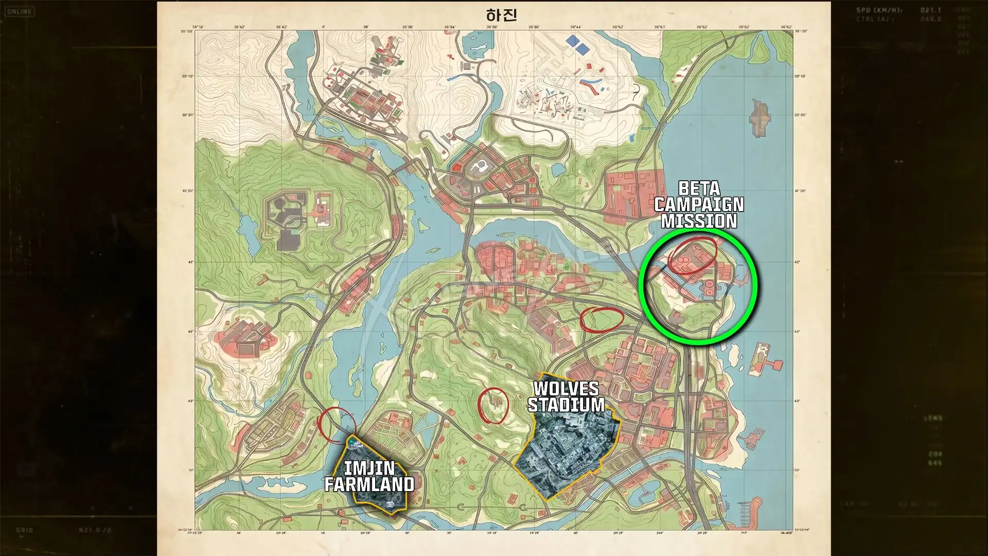
Find the stadium near the bottom center of the map.
Shown at 03:14 in TheXclusiveAce’s video.The stadium and Theatre are Medium threat areas. Take extra care on the northern perimeter adjoining The Grid, where the military presence is heavier. The surrounding streets also contain a police station, bank, courtyards, and small shopping areas. If that is your destination, continue with MW4 DMZ police station.
Hospital, mall, and central mountain routes
Mirae General Hospital sits beside a train station, with Expressway No. 1 to its north and The Grid and NuriGO Mall to its east. Cheonwang Peak Array occupies the central flat-topped summit; its northern woodland slopes lead down toward Mujin Pass near the hospital.
At NuriGO Mall, the courtyard near the old train station has a pavilion and two large light wells leading into the underground shopping district. Bring NVGs for the dark tunnels. The mall's eastern area is Medium threat, while the western area is High.
How big is the MW4 DMZ map?
Hajin contains over 60 named locations, spanning major districts and smaller settlements.
Its underground spaces matter when you plan a route. Chang-san Air Base has a bunker complex larger than the surface base's footprint, and NuriGO Mall extends into a sprawling underground shopping district. A short distance on the overhead map can still involve interior corridors or a change in elevation.
How do you read the Hajin map grid?
Grid letters run west to east, and numbers run north to south; D7 identifies Imjin Farmland.
- Read the letter across the map from west to east.
- Read the number down the map from north to south.
- Give your squad the coordinate and the destination name so they know the general area you mean.
DMZ keys include a grid location in their descriptions. Match that coordinate to the map before looking for the specific door; the MW4 DMZ keys page is your next stop for key details.
Where are the radiation hazards on the Hajin map?
Haneul Nuclear Reactor in northeast Hajin has severe radiation around the complex, with higher concentrations inside the facility.
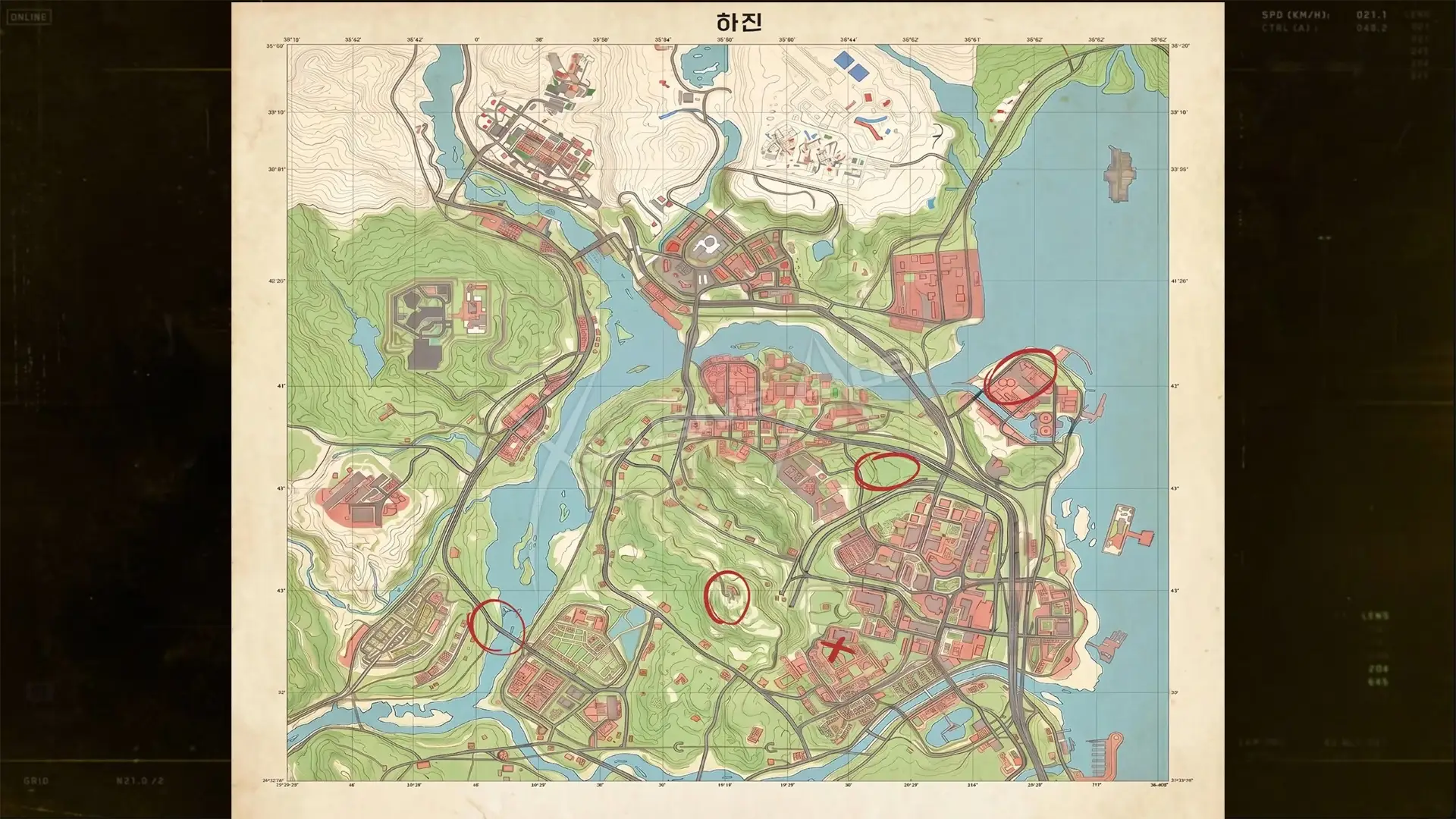
The nuclear facility is marked on the Hajin map.
Shown at 02:41 in TheXclusiveAce’s video.A radioactive vapor cloud is concentrated around the site, with limited atmospheric movement keeping the hazard in the area. Entering requires radiological protective apparel and a gas mask throughout your time in the complex. Unprotected exposure can cause severe injury or death, so avoid cutting through it just to shorten your route.
Other areas punish a careless approach too. The Citadel inside the northwestern prison has a Critical threat level, and its maze of walkways and cell blocks can leave you isolated and surrounded. Chang-san Air Base's exterior is Critical and its bunker is Extreme; the eastern cliffs make infiltration difficult, while elevated woodland to the south offers an approach.
Does the MW4 DMZ map have weather?
Yes. DMZ has a weather system that changes with each deployment: heavy rain, wind and fog, and sunny runs are possible too. Within a run the weather can build, so rain can intensify and make the world wetter, and snow can accumulate. Expect different sightlines from one deployment to the next.
Does the Hajin map have secrets?
The hidden containers and bunkers players call MW4 DMZ secrets are in Stranded, the campaign mission that works as a DMZ preview; their codes are on the MW4 DMZ keypad codes page. In DMZ itself, the secret casino safe next to Heavenly Luck Casino is covered on the safe locations page.
Where can you explore beyond Hajin's main locations?
Smaller locations include Mujin Pass between the hospital and Array, Daesong Ridge northeast of Imjin Farmland, and Oamsik Turtle Island by Songdo Wharf.
At the wharf, look for the seaside market, pier, lighthouse, and coastal rock formations around the island. In the north, Cheongun Village is dominated by Heavenly Luck Casino, whose dark gambling halls favor NVGs. Across the Hajin River to the north lies the inaccessible, fog-filled Russian Border, so keep your route within the accessible village area.
You now have the landmarks and coordinates to place your destination on Hajin before heading in. For an objective to work toward once you know the terrain, continue to MW4 DMZ missions.
FAQ
Hajin. It combines military installations, rural floodplains, mountain terrain, industrial facilities and dense city blocks.
Hajin has over 60 named locations, from major districts to smaller settlements, and underground spaces such as the Chang-san Air Base bunker and NuriGO Mall's underground district add more ground than the overhead map shows.
Grid letters run west to east and numbers run north to south; D7 is Imjin Farmland. DMZ key descriptions include a grid location.
Yes. DMZ in Modern Warfare 4 takes place in Hajin.